Quepos Weather
Manuel Antonio Quepos Weather
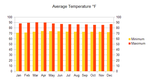
The average precipitation in the valleys is 3500 mm per year. The Pacific rainfall regime is changed by the geographical situation and the protection of the mountain Brunqueña Row. The climate is dry with a short-term and medium to heavy tropical rains, and occurs mainly along the south of the region. The average maximum temperature is 87.8 °F and the minimum average of 72.86 °F.
Average Temperature °F:
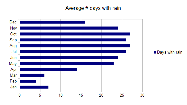
The dry season from January to March, with a 4% of the total annual rainfall. April is a transition month before the founding of the rainy season in early May. The first rainy season is between May and August when rainfall 52% of total. In the second rainy season plunge 44% of annual rainfall. December is a month of transition. The phenomena of variability to divert the normal behavior of precipitation and temperature are primarily connected with the phases of the ENSO (El Niño-Southern Oscillation).
Average number of days with rain:
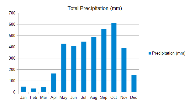
The ends are dry with increasing temperature. The biggest change months are February, March and April, while the rest of the year, temperatures remain virtually unchanged. The precipitation may fall during the rainy season (from May to November) and it is possible to observe an apparent late summer during the month of August. In the rains, the maximum temperature down more than the minimum temperature below average throughout the year, especially in September and November. Precipitation increases, especially in May and October.
QUEPOS Total Precipitation (mm):
So what is the best time to visit Manuel Antonio? The answer is always, because in summer you can enjoy practice water sports, enjoy a catamaran sunset, observe animals or just relax on the beach. But in winter, nature blooms and emerald green is brighter, the days are cooler and you can get some adventure tours such as ATV ride, horseback riding or enjoy guided tours to exotic plantations.
Costa Rica travel map and guide top destinations with distances. Costa Rica Map